Skip to content
Facebook
Instagram
YouTube
DONATE NOW
NEWSLETTER SIGNUP
SHOP
GET INVOLVED
Donate
Marjory’s Circle
2026 Marjory Stoneman Douglas Legacy Celebration
Maggy Hurchalla Opportunity Fund
River of Grass Legacy Society
Third-Party Fundraising
Volunteer
Newsletter Signup
LEGISLATIVE ACCOUNTABILITY
EVERGLADES LEARNING
Young Friends of the Everglades
Educators: Exploration Kit
Karen Mashburn Environmental Scholars Program
The Everglades Handbook
Everglades Glossary
Guide to Visiting Everglades National Park
Everglades Historic Flow Map
Everglades Altered Flow Map
Everglades Restored Flow Map
ISSUES
After “Alligator Alcatraz”
NEW
Rescue the River of Grass
Fighting Toxic Lake O Discharges
Improving the EAA Reservoir
Urban Development Boundary
Methyl-Mercury Pollution
Sugarcane Burning
Climate Action
ABOUT
Mission & Goals
The life of Marjory Stoneman Douglas
Marjory Stoneman Douglas Defender of the Everglades Award
Emeritus Friends
Board of Directors
Staff
Science and Policy Committee
Sponsors
Annual Report
2025 Impact Report
Legal Actions
Employment
Contact
NEWS
Blog
Monthly Newsletter Archive
Search for:
Search for:
Everglades Altered Flow
admin
2025-01-27T12:36:32-05:00
Everglades Altered Flow
WCA 1
WCA 2A
WCA 2B
WCA 3A
WCA
3B
Chain
4
95
27
1
Key West
20 MILES
Gulf of Mexico
Biscayne
Bay
Atlantic Ocean
Atlantic Ocean
10 MILES
BIG CYPRESS
NATIONAL
PRESERVE
WCA 1
WCA 2A
WCA 2B
WCA 3A
WCA
3B
Chain
4
95
27
1
Key West
20 MILES
Lake
Okeechobee
Gulf of Mexico
Biscayne
Bay
Atlantic Ocean
Atlantic Ocean
Historic Everglades Watershed
ARM
Loxahatchee
NWR
Everglades
WCA 1
WCA 2A
WCA 2B
WCA 3A
WCA
3B
Chain
4
95
27
1
Key West
20 MILES
Lake
Okeechobee
Gulf of Mexico
Biscayne
Bay
Atlantic Ocean
Atlantic Ocean
10 MILES
BISCAYNE
NATIONAL
PARK
Shark River Slough
Taylor
Creek
Slough
EVERGLADES
NATIONAL
PARK
Lake
Okeechobee
Holey
Land
WMA
Rotenberger
WMA
A-1
FEB
STA 3/4
STA 2
STA
1-W
STA
1-E
STA
5/6
EAA
STA
EAA
Reservoir
EVERGLADES AGRICULTURAL
AREA
95
95
95
95
95
95
75
595
75
75
75
75
275
275
75
75
TURNPIKE
TURNPIKE
TURNPIKE
TURNPIKE
TURNPIKE
TURNPIKE
TURNPIKE
27
27
27
27
27
27
4
4
4
826
826
874
SOUTH FLORIDA
WATER MANAGEMENT
DISTRICT
BROWARD
PALM BEACH
MARTIN
OSCEOLA
POLK
ORANGE
HIGHLANDS
OKEECHOBEE
POLK
ST. LUCIE
INDIAN
RIVER
BREVARD
SEMIINOLE
LAKE
GLADES
HENDRY
LEE
CHARLOTTE
DESOTO
SARASOTA
MANATEE
HILLSBOROUGH
PINELLAS
PASCO
HERNANDO
SUMTER
HARDEE
MIAMI-
DADE
COLLIER
MONROE
HISTORIC
EVERGLADES
WATERSHED
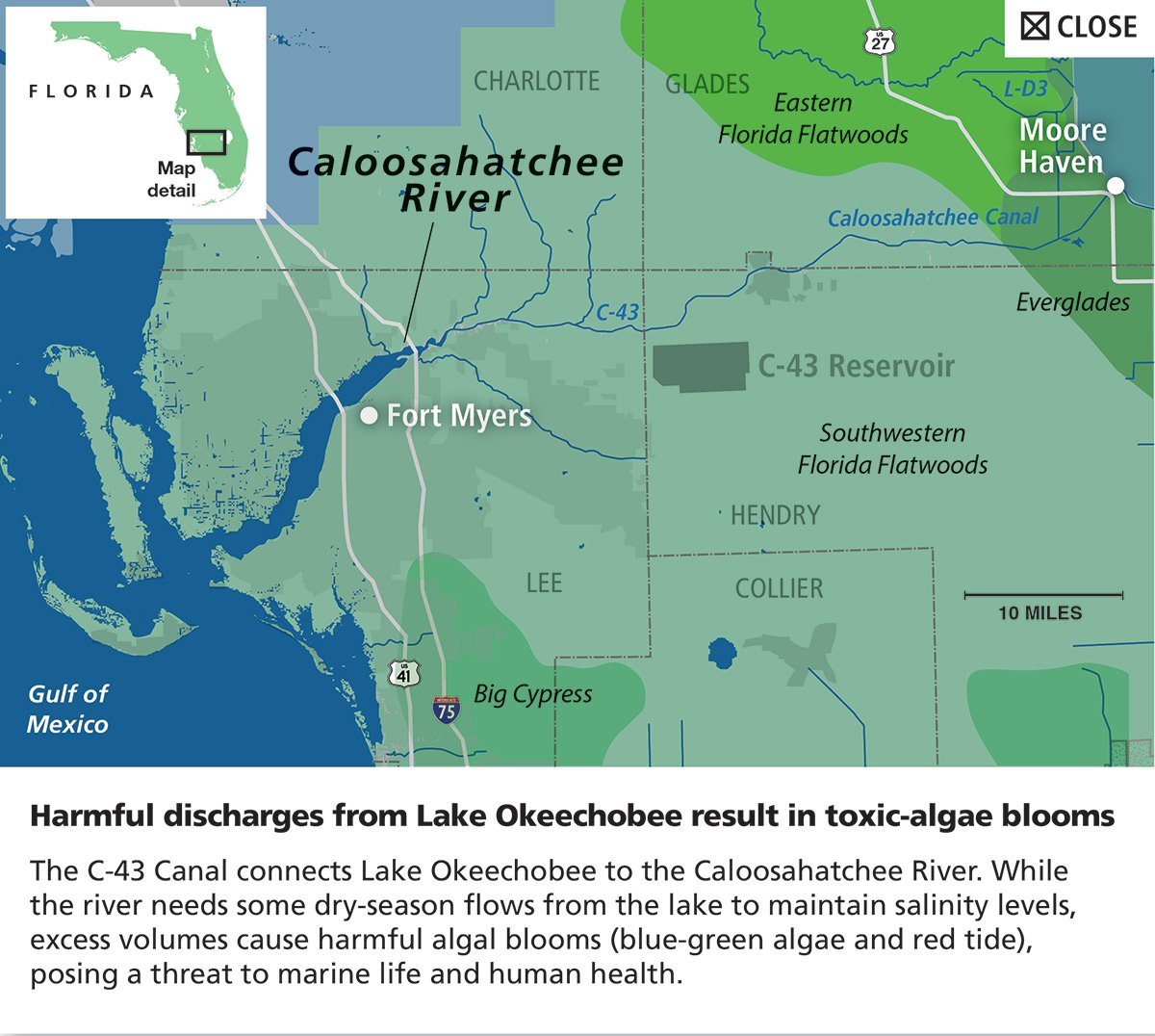
Caloosahatchee
River
St. Lucie
River
Fort Pierce
St.
Tampa
Cocoa
Beach
Petersburg
Port
Charlotte
Orlando
Fort Myers
Port St. Lucie
Miami
K
ey Largo
Naples
Stuart
Kissimmee
Islamorada
Key West
Okeechobee
Clewiston
Belle Glade
Fort
Lauderdale
Flamingo
Homestead
West
Palm
Beach
Jupiter
Florida Bay
LEGEND
Click Boxes to Hide/Recover
Environment
Park Boundaries
Other
Tribal Lands
STAs and FEBs
South Florida Water Management
Sloughs: Shark River & Taylor Creek
Highways
Everglades Agricutural Area
County Names & Borders
City Names & Locations
Seminole Tribe of Florida
Miccosukee Tribe of Indians of Florida
Historic Everglades Watershed
Wildlife Management Area (WMA)
Everglades
Everglades NationalPark
Biscayne National Park
Big Cypress National Preserve
Southwestern Florida Flatwoods
Littoral Marsh
High-Density Populated Areas
Eastern Florida Flatwoods
Central Florida Ridges and Uplands
Big Cypress
Water Flow
Map
detail
FLORIDA
Altered
Everglades
Caloosahatchee River
+
Click to Expand
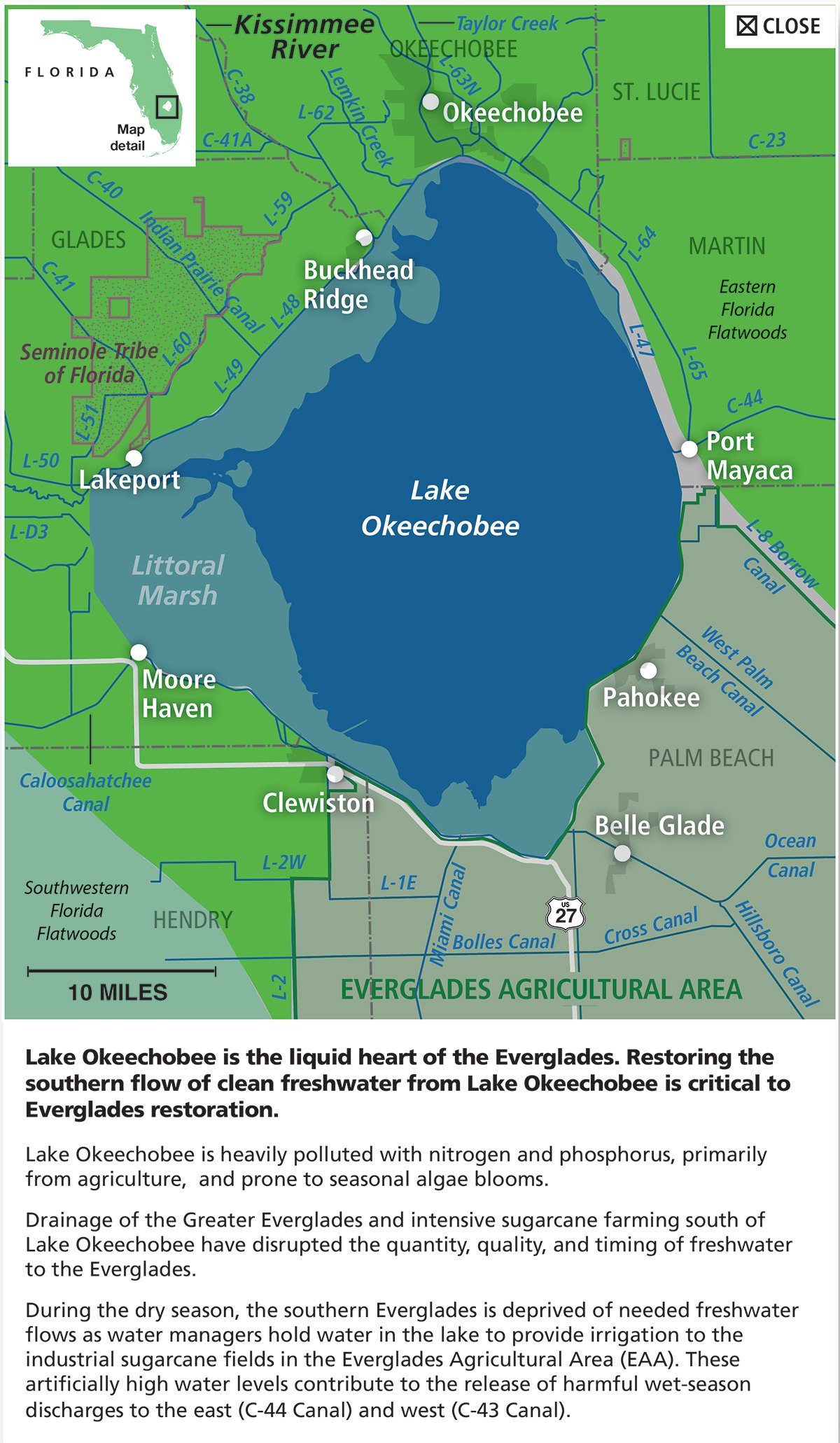
Lake Okeechobee
+
Click to Expand
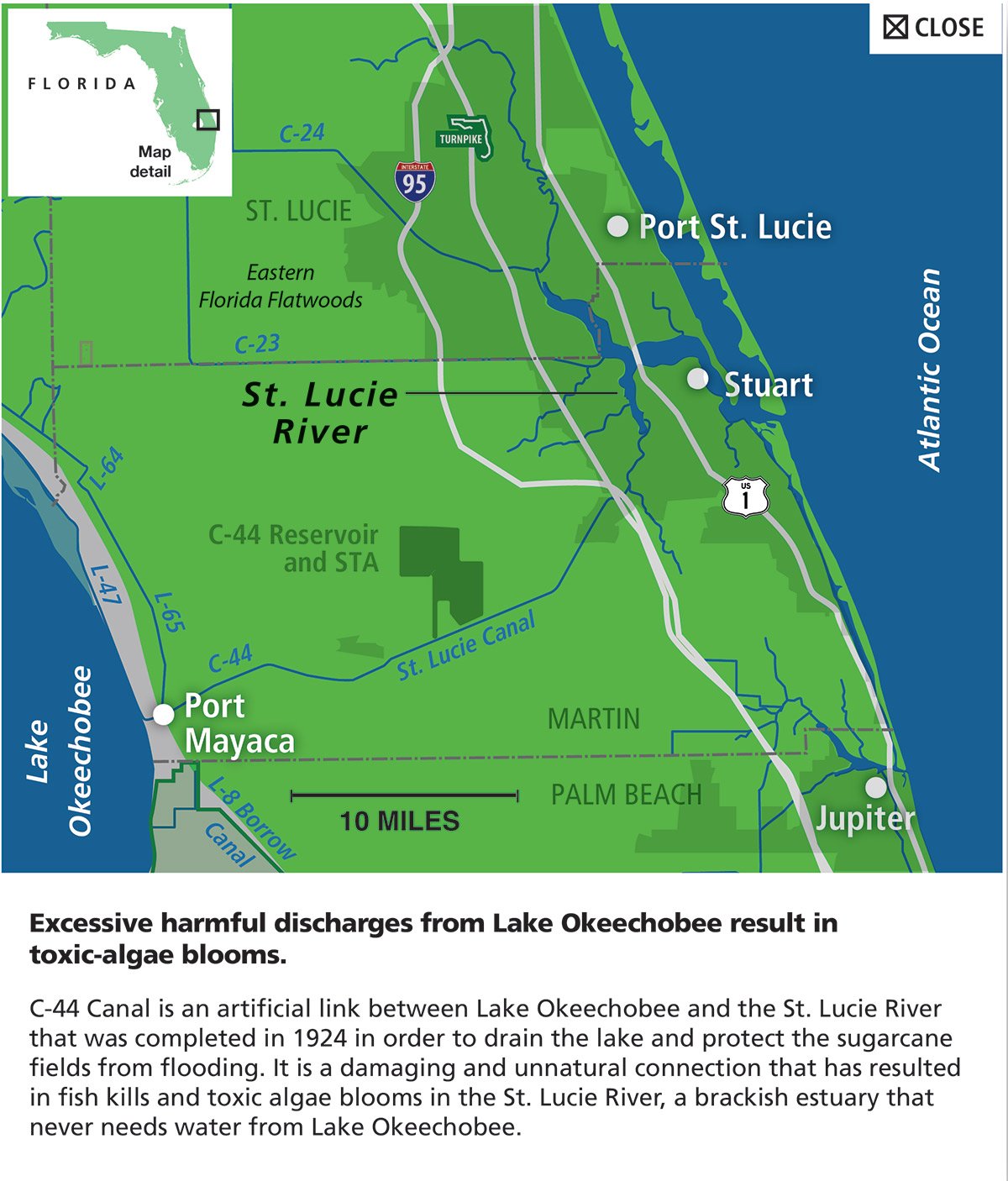
St Lucie River
+
Click to Expand
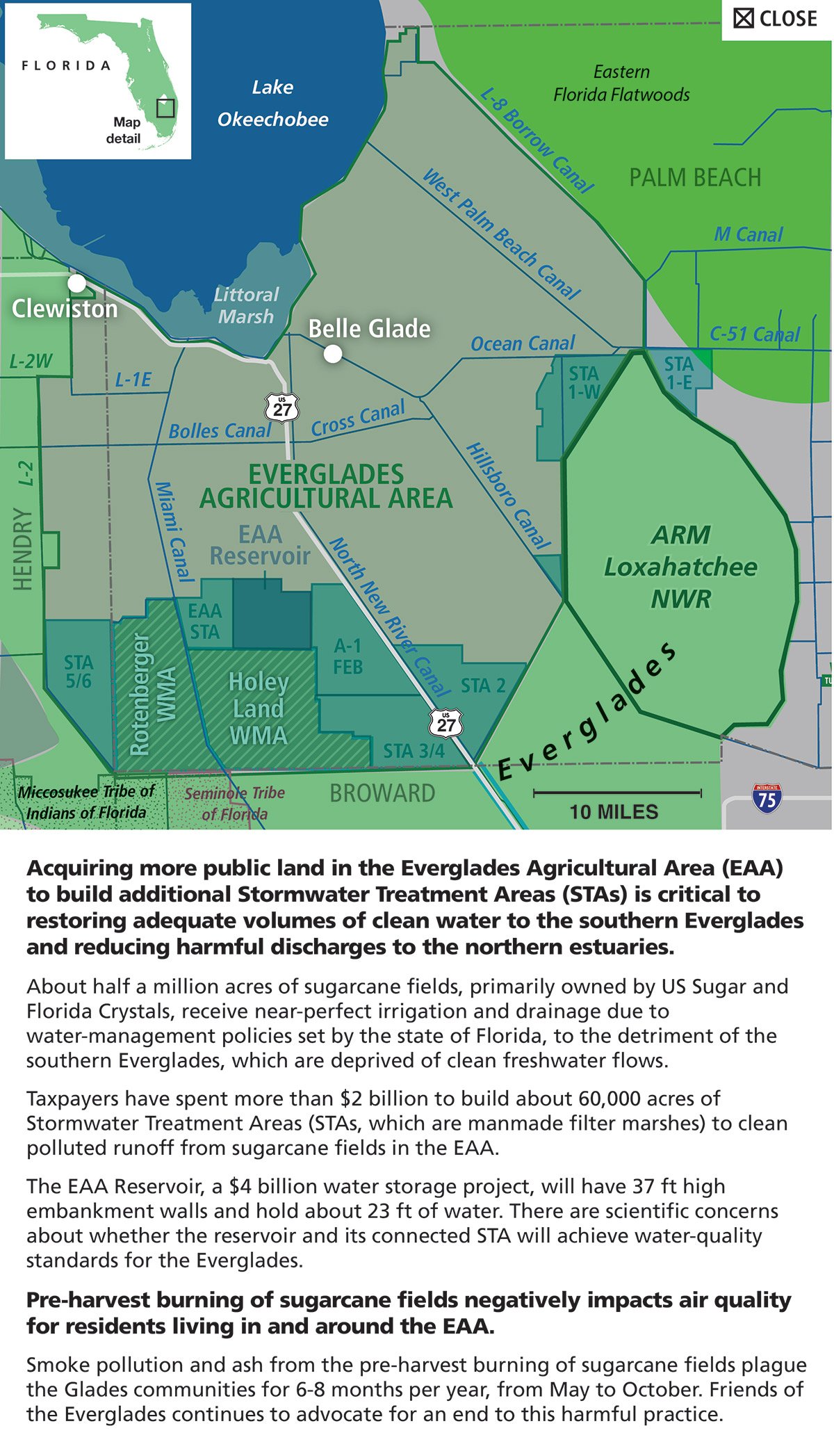
Everglades Agricultural Area
+
Click to Expand
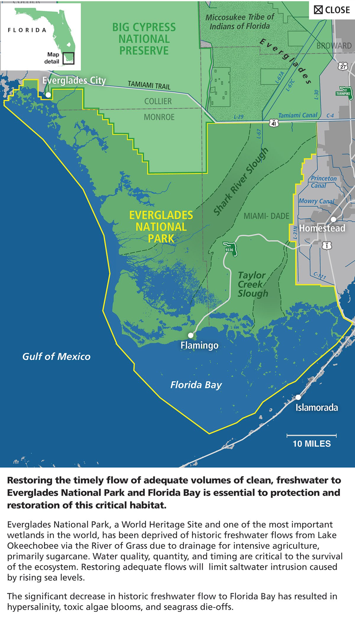
Everglades National Park
+
Click to Expand
See Everglades Historic Flow Map
See Everglades Restored Flow Map
Page load link